
DroneControl Release Update: Enhanced Situational Awareness, Smarter Flight Logs, and Improved Mapping Capabilities
- DroneControl
- 7 hours ago
- 3 min read
At DroneControl, we're committed to continuously improving the tools that public safety teams, enterprise operators, and professional drone pilots rely on every day. Our latest release introduces powerful new capabilities designed to improve operational awareness, streamline post-flight analysis, and provide even greater visibility across your drone operations.
New Laser Range Finder Pinpoint Functionality
DroneControl Flight App now supports enhanced integration with supported Laser Range Finder (LRF) payloads.
When an operator identifies an object through the camera, the laser range finder can be used to accurately calculate its position and instantly drop a pin on the map. This provides highly precise target location information that can be shared with command teams and personnel on the ground.
Once a location has been identified, teams can immediately access:
Precise map coordinates
Postal addresses where available
What3Words locations
Shared location information across DroneControl's operational ecosystem
This capability is particularly valuable for public safety, search and rescue, emergency response, and critical infrastructure operations where rapid and accurate target location is essential.
Camera Pinpoint Calculations for All Supported Drones
We've also introduced Camera Pinpoint Calculations, bringing advanced target location capabilities to a much wider range of drone platforms.

For drones without a laser range finder, DroneControl can now estimate the geographic location of objects observed through the camera by combining aircraft position, camera angle, altitude, and other telemetry data.
While this does not provide the same level of accuracy as a dedicated laser range finder and does not create a map pin, it gives operators valuable location intelligence that was previously unavailable on many drone platforms.
The calculated position can be used to quickly determine:
Approximate coordinates
Nearby addresses
What3Words references
Relative location information for operational decision-making
This enables organisations operating standard camera drones to benefit from enhanced situational awareness and faster target identification without requiring specialist payloads.
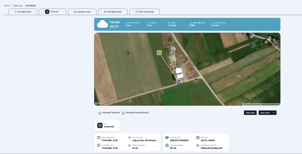
Camera Footprint Added to Remote Viewing Screen
Our Remote Viewing Screen (RVS) continues to evolve into a complete live operations platform.
With this release, viewers can now see the drone camera's live footprint directly on the map, providing a clear visual representation of exactly what area the camera is covering at any given moment.

This enhancement allows remote viewers, incident commanders, and stakeholders to:
Better understand the drone's field of view
Improve coordination between air and ground teams
Increase confidence when directing resources
Gain enhanced situational awareness during live operations
Whether monitoring an emergency incident or conducting a large-area inspection, understanding precisely what the camera can see is a major operational advantage.
Camera Footprint Displayed for Uploaded Media
We've also extended camera footprint functionality into the DroneControl Portal.
When reviewing media uploads within the flight log overview, users can now see the camera footprint associated with captured imagery. This provides valuable context when reviewing mission outputs and helps teams quickly understand where images were captured and what area was covered.
This feature is particularly useful for:
Incident documentation
Infrastructure inspections
Mapping and survey workflows
Evidence collection and reporting
Order and Filter Team Flight Logs
· Administrators and pilots can now quickly sort and filter team flight logs, making it significantly easier to locate specific missions, review operational history, and manage compliance records.
Security Enhancements and Platform Improvements
As always, every release includes ongoing improvements to platform stability, performance, and security.
This update contains multiple security enhancements, bug fixes, and backend optimisations to ensure DroneControl remains a secure, reliable, and enterprise-ready platform for professional drone operations.
Continuing to Build the Future of Drone Operations
These updates are another step toward our vision of creating the most complete drone operations platform available—combining flight operations, live streaming, remote viewing, fleet management, compliance, and situational awareness into a single ecosystem.
We're excited to see how our customers use these new capabilities in real-world operations and look forward to sharing even more innovations in upcoming releases.
For a live demonstration of the latest DroneControl features, contact our team or schedule a demo today.

Comments