
New Release: DroneControl FirstResponder v2.20 Takes Mission Planning & Live Operations to the Next Level
- DroneControl
- Jun 23, 2025
- 2 min read
Updated: Jul 15, 2025
We’re excited to announce the latest release of the DroneControl Ecosystem, featuring a major upgrade to our field app DroneControl FirstResponder and expanded capabilities in the DroneControl Portal. These updates are designed to enhance tactical drone operations, improve mission accuracy, and give control room teams unmatched real-time visibility and responsiveness.
DroneControl FirstResponder v2.20 – Full Waypoint Mission Planning is Here
This release brings full waypoint mission planning to the fingertips of every field operator. Whether you're flying pre-planned inspection routes or setting up perimeter scans for a public safety response, v2.20 gives you more precision, flexibility, and autonomy than ever before.
Key Features:
Mission Types & Workflow
Create Waypoint missions in seconds
Drop points directly on the map to create your waypoint area and the route/legs are automatically calculated

Waypoint Parameters
Choose drone model and camera types
Set GSD level, route altitude and side overlap ration
Toggle Elevation Optimization on or off
Set a safe take-off altitude, mission speed and course angle
Upon completion options include: Exit Route Mode; Return to Home; Land or Return to start point and hover

Mission Behaviour
Pause or stop missions
Choose how missions end: hover, auto-land, RTH, or return to first waypoint
Import, Save & Execute
Import KML/KMZ route files or create routes on the fly
Save and launch with one tap
Full edit of already planned missions
Live stream your predefined mission to command centres for enhanced coordination

Under-the-Hood Enhancements
Upload flight logs even with limited GPS data
Remote Access now toggled on automatically for portal users
Improved WebRTC data stability for cleaner live streams
--------------------------------------------------------------------------------------------
DroneControl Portal – Your Command Centre, Now with More Power
At HQ or in the mobile control centre, the DroneControl Portal continues to lead in remote drone operations. With this update, your team gets an even deeper, real-time connection to what's happening in the field.
Remote Access & Virtual Cockpit
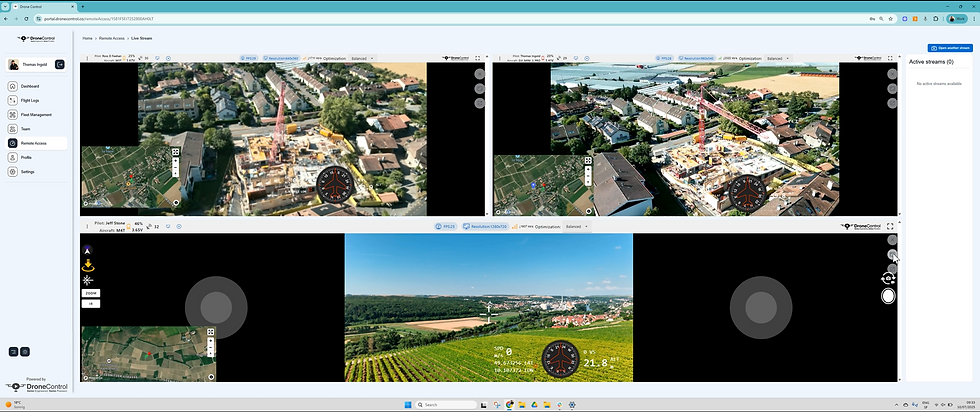
· Supports simultaneous live-streaming from all drones in your organisation.
· Dynamic-layout provides automated-gird view for multiple feeds at once.
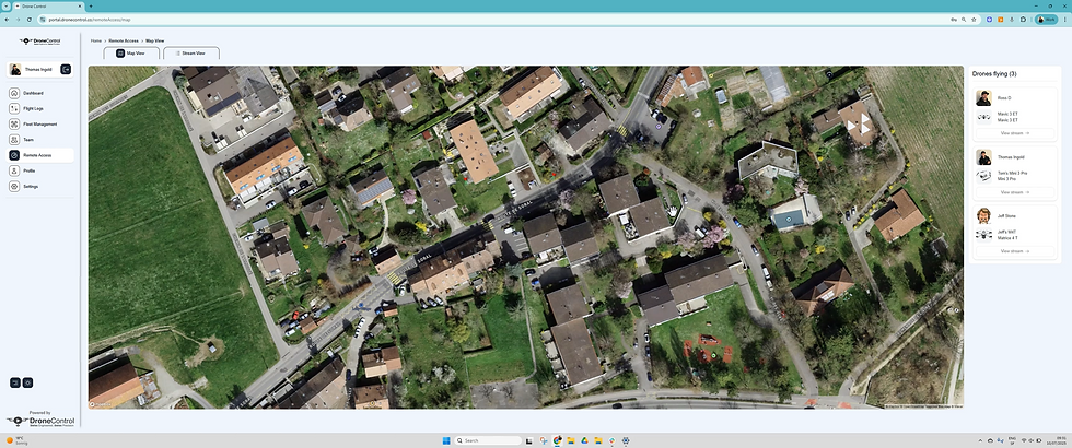
· Map View shows flight tracks, camera FOV, and drone/gimbal orientation in real-time
· The Remote Viewing Screen (RVS) interface allows live remote control: manage flight, adjust gimbal angles, zoom, switch cameras, take photos/videos—all directly from the integrated interface
· Cross-device compatibility enables synchronized situational awareness across laptops, tablets, RCs, and mobile — everyone shares the same live map and data
· Control drones remotely with keyboard, game controller, or mouse – including gimbal adjustments, zoom, camera switching, and media capture
Remote Media Capture*
Record live stream footage locally via the Remote Viewing Screen (RVS)
Trigger and store drone-captured media directly for post-incident review
*requires RVS opened in separate tab outside portal
Security & Interface Enhancements
Improved support for flights with low/no GPS data
Security updates to safeguard mission data
UI upgrades for faster navigation and streamlined decision-making

Why This Matters
Whether you're coordinating a tactical police operation, inspecting critical infrastructure, or managing a large-scale public event, this release ensures you have the tools to plan, fly, and respond smarter.
The new mission planning, live streaming, and remote-control capabilities of DroneControl give teams a tactical edge, allowing for faster deployment, safer operations, and better evidence capture.


Comments